well...a long time since I've written on this blog. In the almost 3 years since my last entry, I've completed a Master's program, was given a warrant as a Contracting Officer where I work, did a tour in Afghanistan and I hope to receive a call soon about winning the HGTV Dreamhome in New Mexico! LOL!!! I have lots of new adventures past and present to post - Jeff earned his Commercial helicopter rating so I will show you some of these personal experiences with rogue aircraft buzzing in Alaska's sky's. I will be posting soon! M
Crow Pass to Eagle River Trek
 17 August 2007 – the adventure began early that morning, by 6AM we had ordered breakfast and by 6:30 we had eaten and had driven out of the parking lot on our way to Girdwood some 40 miles south of Anchorage up to the Crow Pass Trailhead. We reached the trailhead around 7:30AM.
Crow Pass is a steady climb, on a well defined trail for the first 7 mi. In June 2006 we traversed over 3 avalanche slide areas in order to reach the falls at the top of the pass – we never reached the falls. That day was glorious, I had plastic bags (the kind you get at Wal-Mart to carry your items out in) using these to slide down the chutes on our butts, we were soaked but it was fun.
 This day Jeff and John will hike 26 miles one-way from Girdwood to Eagle River. I am supposed to pick them up around 11PM. Today the sun goes down around 8:50 PM. On our end of the trail, very dark clouds moved in up and over the canyon where Jeff and John are to immerge in 6 hours – I knew something wicked was knocking at their heart strings – rain, cold, wet, walking through a dense forest wrapped in a cloak of darkness, they would come. In the meantime, here are some choice words about their trip!
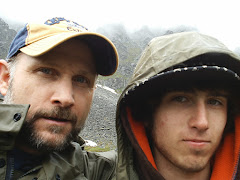
 Behind Jeff is the trail - coming off his left shoulder - if you follow this around the side of the mountain and to the left of the ridge - this is where the trail head starts - and is about 3.5 mi to the cabin which is just ahead. “We reached the top of Crow Pass Forest Service Cabin in just a couple of hours. It was about 10AM. The sun was shining, it was really pretty – we had good weather pretty much the whole way; we could see the storm coming, it followed us for most of the day.”
  At the top of Crow Pass, past the Cabin is Raven Glacier (pic below)– this area has glaciers named after birds – Crow, Raven and Eagle are most known. Eagle Glacier feeds the Eagle River and this is coincidently the name of the town located below the canyon. Eagle River is a nice town located about 10 miles north of Anchorage and has stunning views of the Chugach Mountains to the East, the Alaska Range to the west, and Mt. McKinley (Denali) to the North. On a clear day you can see Anchorage and the Cook Inlet depending where you are standing. On a really clear day, depending where you are standing, you can see Mt. McKinley which is over 200 miles to the north as the crow flies and I wish everyone could see that.
 ← This is below Crow Pass looking back up the mountain from where they just came down.
→
This is a water fall - the water is literally pouring out of the mountain - this is perhaps a most intriguing phenomena inpsiring me to make this trek, to that point, next summer.

← This is the bottom of the falls. Further down from here Jeff and John saw 2 bear walking, eating, and just plain in the way of getting through the valley. John had an air horn and began making his loud noise - as they descended, the bear became more clear - they were actually moose.

Lunch break at the Eagle River ford area. The "ford" is where they are going to cross the river and is about 13 mi into the trip. The pic below - if you look closely - you should be able to see a white post on the other side of the river - this is the target you WILL make every attempt to stay on course to. This is important as the river is full of surprises. The water is "glacier" cold and it "makes your feet hurt" as you walk through to the other side.

 The otherside - it looks like the current and cold took all the hair off John's legs.


 The pictures stop here at Icicle Creek as the weather finally caught up with them. Icicle puts them 5.7 mi to their destination and as you can see, it was dusk. Sunset is 8:50 - this pic was taken around that time...and then...the rains came. Jeff says it "got real dark at Echo Bend" - Echo Bend is "3.0 mi to go!" This is the point on the trail where you leave the river for the forest.

← This is the bottom of the falls. Further down from here Jeff and John saw 2 bear walking, eating, and just plain in the way of getting through the valley. John had an air horn and began making his loud noise - as they descended, the bear became more clear - they were actually moose.

Lunch break at the Eagle River ford area. The "ford" is where they are going to cross the river and is about 13 mi into the trip. The pic below - if you look closely - you should be able to see a white post on the other side of the river - this is the target you WILL make every attempt to stay on course to. This is important as the river is full of surprises. The water is "glacier" cold and it "makes your feet hurt" as you walk through to the other side.

There was another hiker on the trail that morning - he showed up while they were eating lunch at the rivers edge. He had walking poles and crossed in front of Jeff while John followed behind. Could he have been one of God's guides? Jeff said he was camping at the cabin and caught up with them. The man poked his way across the river, Jeff and John following, leading them around holes/pockets at the rivers bottom. Do you see the white post on the other side of the river...the river had 2 tributaries which had to be crossed and this was not the end of river crossings - the Icicle Creek bridge had washed out in between our hike up a couple of weeks before their trip. This fierce, deep, little creek is nothing to scoff at - it is a wicked little creature -this creek is found at mi 20 and was crossed in the dark as you will see soon.
 The otherside - it looks like the current and cold took all the hair off John's legs.
This trail is actually a portion of the historic Iditarod Trail. The Iditarod Trail was a trail that connected a point 80 km (50 miles) north of Seward, Alaska, where a forerunner of the Alaska Railroad ended, through Iditarod, Alaska and then to Nome. The trail was about 1,850 km (1,150 miles) long. From its beginning, the trail wound along Turnagain Arm, over Crow Pass, down the Eagle River Valley and northward to the trading post of Kink, Alaska, the largest town on the Upper Cook Inlet until the railroad town of Anchorage was founded in 1915.

← This is Twin Falls which is approximately 16.5 mi from the Girdwood trail head and "9.5 miles to go." 

→
This is a pic of the Eagle Glacier - this is a zoom looking back from the Eagle River side of the Trail. This massive glacier feeds the Eagle River which flows into the Cook Inlet.
 The pictures stop here at Icicle Creek as the weather finally caught up with them. Icicle puts them 5.7 mi to their destination and as you can see, it was dusk. Sunset is 8:50 - this pic was taken around that time...and then...the rains came. Jeff says it "got real dark at Echo Bend" - Echo Bend is "3.0 mi to go!" This is the point on the trail where you leave the river for the forest.
Jeff says you could still see, but shadows were your guide which played in their minds - well, in John's mind anyway. Jeff says this "is when John came alive."
John was talking, using his horn, singing - I can imagine. The area is littered with wild animals, bear, moose, squirrels - there is no telling when one of these will jump at you from the nearest tree - I'm kidding! Moose can't climb trees. "It's important, you want to make noise - you don't want to sneak up on a bear."
In my minds eye the Eagle River side of the trail is a pain in the --- to hike over - you have rocks jutting up all over the trail, tree roots spread intermingled between the rocks - some parts of the trail are very narrow and close to the rivers edge - one slip or lean in the wrong direction and you could find yourself in the drink being pulled by the roots and rivers current. This side of the trail has a lot of designated camping spots and most campers come in at dust/night - which is a common practice on all the trails we have hiked. The animals are out at dust, hunting/foraging, which makes for the perfect photo op.
I had been sitting in the truck at the Visitor Center waiting for their arrival for the past 30 minutes. It was late, I was tired, the rain was relentless, it was dark. I rolled my window down just enough to hear the sounds of night when I heard what sounded like wolves in the distance. Many residents own half wolf, half Husky dogs - these howling sounds are not uncommon to Alaska. I could hear the owner yelling at the dogs to be quiet. About this time I decided to hit the horn - listening for a response - nothing. 15 minutes had passed when I hit the horn - toot, toot, toot - I heard a blast! It was John's air horn - they were close now but still had a few more minutes before they would reach me. It was 1115 when they came from the other side of the center - the end of the trail. They were happy to see me - I was happy to see them - the chatter home was unending - Jeff says they ran about 3 miles as it rained - the adventure was fantastic.
How to Read this Blog
In order to fully enjoy this story, you need to read the Reeds Lake Treks from the bottom up. Enjoy the site! M
Reeds Lakes Trek #4 - The Big Bomber
 11 August 2007 – Jeff, who is completely obsessed with making it to the Bomber, bribed John and John gladly accepted the challenge as it meant new bike parts. John is into BMX, park style biking and that is another story. It was a nice day, sun was out and now, the rest of the story.
Along the way they spotted rock Ptarmigan – they hang out in gray rock and they are gray – they hang out in gray rock with white moss, they are gray with white spots – when the snow flies, they turn white to hide in the snow. While they are young you can touch them, turn them on their back and rub bellies – they will sleep at this point – trusting, fearless, cute.

Once they reached the glacier around 6PM they began walking toward the bomber crash site – someone said, you can walk on the glacier, it's not slick. They failed to mention that the first part of the assent is steep, slick, and you can lose footing on the crust, created by the sun that day, of the glacier and end up in an unknown crevasse – we recommend crampons if you can’t walk on ice crush slopes in hiking boots. Jeff and John took lots of pics – the area was littered with debris from the Bomber.

During this hike the snow had melted significantly exposing the crash site and debris. Photo’s we’ve seen on the site show a man standing by the plaque posted on the aircraft…Jeff his standing a head below the sign which is about 6 feet from the bottom of his shoes.

The man in the photo we saw On-line, was eye level standing next to the sign. The snow had melted a good 2 feet between the time he went and Jeff's trip up.

The Trek down - a needed rest. Notice the sharp little peak if you follow John's hood straight up. Just to the right of this peak is where they just came from - from there, it is another 1.25 - 1.50 miles from the peak to the Bomber.
So, Jeff finally made it to the glacier - John made it to the glacier and both arrived home around 2:00 the next morning. And then...there is next summer.

Reed's Lakes Trek #3 - The Big Rally

28 July 2007 – Jeff, who is passionate about making it to the Bomber, rallied Laura. Laura, hearing about how beautiful it is up at Reeds, gladly accepted the challenge. What started out as a nice day turned into weather chaos. They reached Upper Reeds and found the trailhead to the glacier. Like the trip before, they had to traverse their way to the top of the mountain ridge through a river of steep, sharp, and loose rocks laid down by years of erosion. Mind you, we are way above tree line - the mountains are made of pillars of rock and this rock over the years has broken off creating slides.

The trail went on up one such slide into a chute and if you choose the wrong chute, you could end up in a position you don’t want to be in. On their way up it began to rain sheets and peels of thunder and it was beginning to get dark and past dangerous. Once they reached the summit they could barely make out the Bomber resting on the glacier through the rain. Jeff could see the Bomber from the ridge when the lightening flashed. Jeff and Laura didn’t make it to the glacier and arrived home after a dark trip down the mountain around 2:30 the next morning.
Reed's Lake Trek #2 - The Big Bribe

04 July 2007 – Jeff, who has been preoccupied with making it to the Bomber, bribed John into hiking this day. From the trailhead to Upper Reeds is 4.5 miles. It’s a time consuming hike and it’s all up hill both ways...depending if the glass is half full or half empty. Jeff and John didn’t make it to the glacier but they did find the correct path to the galcier. They arrived home around 1:30 the next morning.
Something wicked this way came and it was called weather. Unpredictable Alaska weather has claimed many lives. It's best to always be prepared for the worst and expect the best.

Reeds Lakes Trek #1 - The Big Scout
Surveying Reed’s Lakes -this first hike Jeff and I took was to scout the area to the Bomber Glacier. It was a pretty nice day, not too hot with intermittent mist to cool you just enough to make the trip worth while. The first part of the trail is light walking, until you reach that part which is made up of rocks to twist your ankles – this is for a short distance and long enough to take the fun out it.
The trail head opens again to well traveled ground, a couple of bridges to traverse, an old cabin to view – lots of mud on the trail so you needed to be prepared to get dirty. From the cabin it’s a hike up, up, and away!  I didn’t enjoy this – my heart loved it and I lost 2 pounds. Once you reach this first summit you begin the
 climb down into the boulders - a very old rock slide that covers the river which is fed from the lakes.
The boulders can be challenging when wet – we covered about ¾ mile on and in-between boulders. Marmots were whistling, and later the Beavers came out to greet us and the evening cover. We stopped at the falls between Upper and Lower Reeds for lunch.
After lunch we scouted and climbed an area we thought might lead us to the glacier – after 200 feet we could see where we needed to go and that was back down and up, up to the Upper lake. The directions we found on line were not very clear making it difficult to know if Lower Reeds was actually Upper Reeds; further, the trail was not well traveled at the time so we lost it until we climbed above it.
Once we reached Upper we needed to scout a path to the glacier – we met a couple on the trail who had a GPS, they pointed where they thought the glacier path should lead. It was 8PM and 8:30 before we finally headed down. We hit the parking lot at 11:00 and still had 20 minutes before our cell phones worked to call the kids…our trip was a success.
Subscribe to:
Posts (Atom)